• Animals
  • Food
  • Geography
  • History
  • People
  • Plants
  • Science
  • Myths & Other Info
  • Places
  • Architecture
  • Places

Informative Facts

Learn Facts and Info Everyday

  • Privacy Policy
  • Home
  • Contact Us
  • About Us

Facts About Thal Desert

March 17, 2019 By admin 2 Comments

The Thal desert is located in the Punjab Province of Pakistan. As it’s a desert, there’s sparsely any vegetation present. Only a small area of the desert is cultivated with crops.

Thal Desert
Author: Iloveshadia / (CC BY-SA 3.0)

Thal Desert has an approximate area of 20000km2.

It’s also the third largest desert in Pakistan.

The desert extends over a length of 305km and has a width varying from 32km to as much as 112km.

It lies south of the Pothohar Plateau between the Jhelum and Sindh rivers.

It covers the Bhakkar,Khushab,Layyah,Mianwali,Muzafargarh and Jhang districts.

A tree in the desert.
Author: Jugni / (CC BY-SA 3.0)

Vegetation in the desert is sparse. The only natural vegetation in the desert are a few species of drought resistance grass, shrubs and trees.

The desert is supplied with water from the Thal Canal. Villagers use this water for irrigating their crops and feeding their cattle.

Locals speak Urdu, Saraiki and Thalochi, a modified dialect of the Punjabi Language.

Approximately 50-60% of the desert is covered in sand dunes.

Gram fields in the desert.
Author: Armaghan Uddin Khan / (CC BY-SA 4.0)

June is the hottest month in the desert, during which the average temperature is about 34°C.

Temperatures in the desert can go as high as 44°C and reach as low as 0°C .

Average rainfall in the desert is about 277mm per year.

The desert is also a famous and attractive spot for rally racing.

Although, the area is quite backward and most of the locals are poor who depend on cattle rearing as the main source of income, the desert’s cultivated land area could be increased by using more sophisticated farming techniques. This could greatly improve the living standards of the local population.

A road passing through the Thal Desert.
Author: Vasiq Eqbal / (CC BY-SA 4.0)


Facts About Mount Vinson: Tallest Mountain in Antarctica

March 7, 2019 By admin 2 Comments

The mountain itself is a collection of many peaks and is also referred to as the Vinson Massif. It’s located in the Ellsworth mountain range of Antarctica. Although it’s not as tall as the mountains of Himalayas and the Karakoram and is only about half the size of Mount Everest, it’s still the tallest peak on the continent of Antarctica and still a massive mountain.

Mount Vinson
Author: Christian Stangl / (CC BY-SA 2.0)

Vinson Massif was discovered by a United States Navy aircraft in January 1958.

In 1961, the mountain was named Vinson in honor of American Congressman Carl Vinson.

The Mountain has a height of 4892m.

The summit of the Vinson Massif.
Author: Victor L. Vescovo / (CC BY-SA 3.0)

The Vinson Massif is 21km long and 13km wide.

It’s located about 1200km away from the South Pole.

Snowfall on the mountain is very low but due to high pressure winds, temperatures can drop to about -30°C to -40°C.

Mount Vinson Base Camp.
Author: Christopher Michel / (CC BY 2.0)

Vinson Massif is abundant in glaciers and icecaps.

The mountain was first climbed successfully on 18 December 1966 by a group of 10 Americans. The expedition was led by climber Nicholas Clinch.

More than 1000 people have climbed this mountain.

Planes parked at Mount Vinson base camp.
Author: Christopher Michel /(CC BY 2.0)

The world record for reaching the summit of Mount Vinson is held by climber Dave Hahn, who has done it 37 times.

Although the climb itself is not very technical or challenging, the low temperatures and high pressure winds make it difficult for an inexperienced person to climb the peak.

It costs about $43000 to climb the mountain. This cost includes air travel from Chile, the closest country to Antarctica.

Facts About Vinicunca: The Rainbow Mountain

March 3, 2019 By admin Leave a Comment

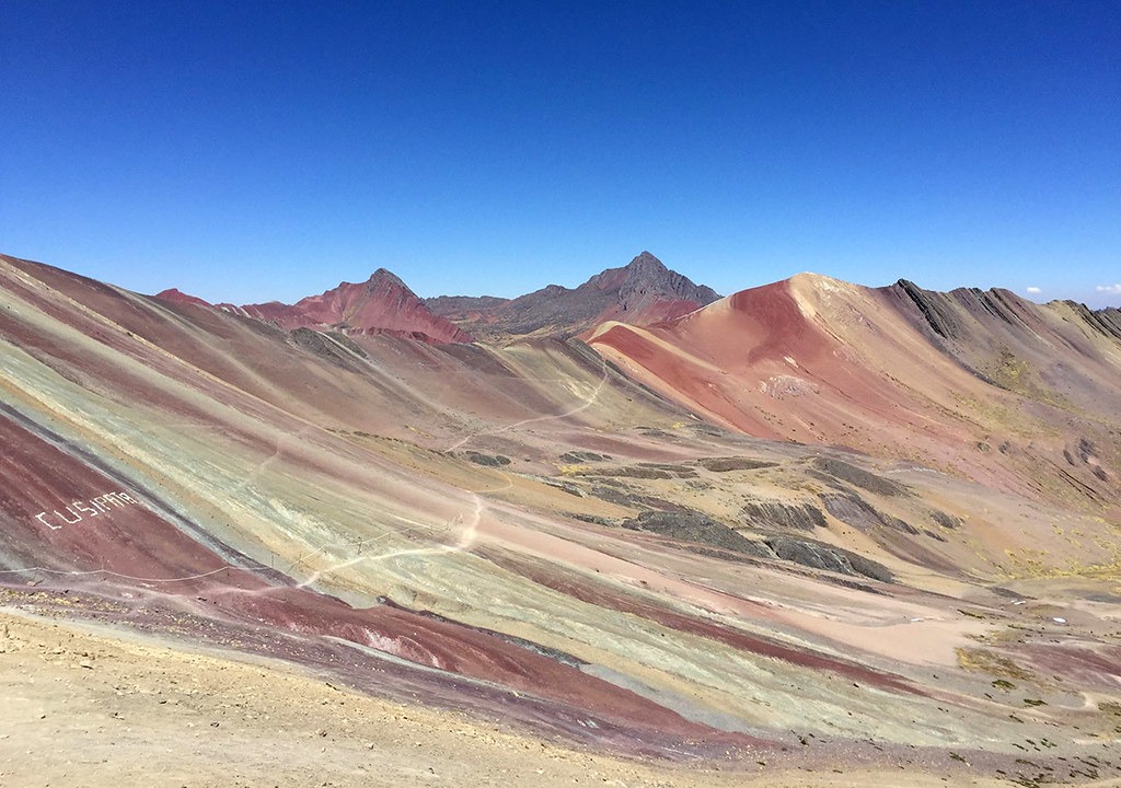
Located in the Andes Mountain Range in Peru, this mountain is known for its rainbow colored appearance. It was discovered by hikers only 6 years ago.

Author: Peruwikila / (CC BY-SA 4.0)

It lies in the Cusco district in Peru and is part of the Andes.

The mountain has a height of 5020m.

The mountain was initially covered in ice and snow but due to global warming the thick layers of ice melted away revealing beautiful color patterns on the mountain’s surface.

The different colors are attributed to the presence of different type of minerals on the mountain.

Each type of mineral on the mountain has a unique color and hence different types of color patterns can be seen on the mountain’s surface.

Vinicunca Mountain
Author: Viaggio nel Mondo / (CC BY-SA 2.0)

The red colored patterns are due to the presence of iron oxide. Green color is associated with chlorite. White is associated with sandstone.

And more color patterns are produced by other types of minerals. Also, some mineral sediments mix together producing new colors on the mountain surface.

The mountain was discovered in 2013.

Ever since the Vinicunca mountain was discovered, it has become an important hiking spot and tourist paradise. However, this has had a negative impact on the mountain’s beauty. Continuous hiking has caused erosion on the mountain surface and is damaging its geography.

Vinicunca Mountain
Author: Christian Morales Callo / (CC BY-SA 4.0)

Facts About Zhob River

March 2, 2019 By admin Leave a Comment

The Zhob River flows through the Khyber Pakhtunkhwa and Balochistan provinces of Pakistan. It is an important source of water for irrigation purposes in the drought prone Balochistan province.

Author: Adilswati / (CC BY-SA 4.0)

Facts About the River:

  • The word ‘Zhob’ comes from Pashto Language. It means ‘oozing water’.
  • Zhob River has a total length of 410km.
  • The river receives water from the Sulaiman mountain range. Monsoon rainfalls also fill the river during summers.
  • The river flows at a speed of about 2km/h.
  • The depth of the river varies between 1 to 3.5 meters.
  • Zhob City in Balochistan is named after the river.
  • The atmosphere temperature near the river is between 23-33°C.
  • Temperature of the river water ranges from 20-28°C.
  • Fishing is an important source of income for people living near the river
  • Zhob River is home to about 19 different types of freshwater fish.
  • It’s the only river in Pakistan, that flows in the north-east direction.
  • Major birds found in the river wetlands are Cranes,Pelicans,King Fishers and Osprey.
  • The Zhob River eventually joins the Gomal River at Khajuri Kach in Balochistan.

Historically, Zhob Riber has been an important source of water for agriculture purposes. However, the river bed has suffered significant degradation over the years and this has created problems for many local farmers who solely depend on the river for irrigating their crops.

Facts About the BRB Canal: Lahore’s First Line of Defence

February 23, 2019 By admin 6 Comments

Author: Abbas dhothar / (CC BY-SA 4.0)

BRB canal is a long canal running through Lahore, Pakistan. The canal runs along the eastern boundary of Lahore near the border with India. Historically, the canal has significant importance, especially during the Indo-Pak war of 1965.

Facts About the BRB Canal:

  • BRB is short for Bambawali-Ravi-Bedian.
  • The canal is about 72km long in length with a depth that varies between 14-18 feet.
  • The water in BRB flows with relatively much greater speed than the rest of the canals in the city. Because of this, it’s banned to swim at some places in the canal. There have been incidents of people drowning in the canal because of the fast flowing water.
  • It was built in 1948 voluntarily by the citizens of Lahore on the request of the Chief Minister of Punjab, Nawab Iftikhar Hussain Khan.
  • The canal was built as a natural line of defence in case of an attack from india.
  • It is located only 2km away from Pakistan’s border with India.
  • Several bridges were also built over the BRB to allow movement across it.
  • The canal is also known as the Ichogil Canal.
  • During the Indo-Pak war of 1965, Pakistan Army destroyed almost all bridges across the canal. The Army stood guard on the remaining bridges to defend against attacks from the Indian Army.
  • Major Aziz Bhatti, A Pakistani war hero, died fighting near the canal. He was awarded Nishan-e-Haider, the highest military honor of Pakistan.
  • The BRB was part of a major battlefield during the war in which Pakistani forces were successfully able to defend Lahore from an Indian invasion.
  • Several stories of the war have been associated with the BRB.

Although, the canal has not much strategic importance in present times, it’s still remembered for the significant role it played during the Indo-Pak war of 1965.

Facts about Baintha Brakk(The Ogre) Mountain

February 23, 2019 By admin Leave a Comment

Baintha Brakk is located in the Panmah Mountains in the Karakoram Range. This mountain peak is known for its steep ridges and bumpy terrain. Because of its dangerous terrain it’s not climbed much by mountaineers.

Baintha Brekk, also known as ‘The Ogre’
Author: Ben Tubby / (CC BY 2.0)

Facts about the Mountain:

  • The peak lies to the north of the Biafo Glacier.
  • It is about 75km away from the small tourist town of Skardu, which is a hub for tourists.
  • The mountain has a height of 7285 meters, making it the 86th highest mountain in the world.
  • The mountain has a tough climb and has only been successfully climbed twice.
  • The first successful ascent was in 1977 when two British climbers were able to reach the peak.
  • The second successful attempt came 24 years later in 2001.Three climbers were able to reach the summit of the peak.

Baintha Brakk is often avoided by climbers because of its extremely difficult climb. Few people have tried to climb this mountain and only 5 people have been able to reach the summit. Since 2001 no one has been able to reach the top.

  • « Previous Page
  • 1
  • 2
  • 3
  • 4
  • Next Page »

Copyright © 2025 Informative Facts