• Animals
  • Food
  • Geography
  • History
  • People
  • Plants
  • Science
  • Myths & Other Info
  • Places
  • Architecture
  • Places

Informative Facts

Learn Facts and Info Everyday

  • Privacy Policy
  • Home
  • Contact Us
  • About Us

Archives for March 2019

Facts About Thal Desert

March 17, 2019 By admin 2 Comments

The Thal desert is located in the Punjab Province of Pakistan. As it’s a desert, there’s sparsely any vegetation present. Only a small area of the desert is cultivated with crops.

Thal Desert
Author: Iloveshadia / (CC BY-SA 3.0)

Thal Desert has an approximate area of 20000km2.

It’s also the third largest desert in Pakistan.

The desert extends over a length of 305km and has a width varying from 32km to as much as 112km.

It lies south of the Pothohar Plateau between the Jhelum and Sindh rivers.

It covers the Bhakkar,Khushab,Layyah,Mianwali,Muzafargarh and Jhang districts.

A tree in the desert.
Author: Jugni / (CC BY-SA 3.0)

Vegetation in the desert is sparse. The only natural vegetation in the desert are a few species of drought resistance grass, shrubs and trees.

The desert is supplied with water from the Thal Canal. Villagers use this water for irrigating their crops and feeding their cattle.

Locals speak Urdu, Saraiki and Thalochi, a modified dialect of the Punjabi Language.

Approximately 50-60% of the desert is covered in sand dunes.

Gram fields in the desert.
Author: Armaghan Uddin Khan / (CC BY-SA 4.0)

June is the hottest month in the desert, during which the average temperature is about 34°C.

Temperatures in the desert can go as high as 44°C and reach as low as 0°C .

Average rainfall in the desert is about 277mm per year.

The desert is also a famous and attractive spot for rally racing.

Although, the area is quite backward and most of the locals are poor who depend on cattle rearing as the main source of income, the desert’s cultivated land area could be increased by using more sophisticated farming techniques. This could greatly improve the living standards of the local population.

A road passing through the Thal Desert.
Author: Vasiq Eqbal / (CC BY-SA 4.0)


Facts About Giant Himalayan Lily

March 9, 2019 By admin Leave a Comment

Giant Himalayan Lily is a species of flowering plants belonging to the Lily plant family. Scientifically known as the Cardiocrinum giganteum, the plant is mainly found in the Himalayas and parts of China, Pakistan, India, Bhutan, Myanmar and Nepal.

Giant Himalayan Lily
Author: Lokal_Profil / (CC BY-SA 3.0)

The name Cardiocrinum is derived from Greek which means ‘Heart Lily’. It was named as such due to the plant having heart shaped leaves.

Giant Himalayan Lily is often nicknamed ‘Queen’ or ‘King’ of the garden because of its tall height and relatively big flowers and leaves.

The plant was first scientifically described in 1824 by Nathaniel Wallich, a Danish botanist.

It takes about 5-7 years for the plant to fully blossom after the seeds sprout.

A giant lily in one of its native habitats, in China.
Author: Ernst Gügel / (CC BY-SA 3.0)

The flowers of Giant Lily are usually white with red colored centers.

Some of these plants produce greenish flowers with purple colored centers.

These plants can reach up to to 3m in height.

Giant Lilies are usually grown on high altitudes, but many gardeners have successfully grown them at lower altitudes.

Each Giant Lily plant can grow up to 20 flowers.

Himalayan Lily in Bhutan.
Author: A. J. T. Johnsingh, WWF-India and NCF / (CC BY-SA 3.0)

Leaves of the plant can grow up to 30 cm in length.

It’s flowers are about 15-20 cm long.

As it’s native to the Himalayas, the plant can survive temperatures as low as -10°C.

The plant is used in some herbal pastes to cool and relieve pain caused by skin burns and other wounds.

Although as the name implies, the Giant Himalayan Lily is more suitable to grow in conditions like the Himalayas. But if provided with proper care and the required environmental conditions they can grow almost anywhere.

Giant Himalayan Lilies in a garden
Author: Lokal_Profil / (CC BY-SA 3.0)

Facts About Mount Vinson: Tallest Mountain in Antarctica

March 7, 2019 By admin 2 Comments

The mountain itself is a collection of many peaks and is also referred to as the Vinson Massif. It’s located in the Ellsworth mountain range of Antarctica. Although it’s not as tall as the mountains of Himalayas and the Karakoram and is only about half the size of Mount Everest, it’s still the tallest peak on the continent of Antarctica and still a massive mountain.

Mount Vinson
Author: Christian Stangl / (CC BY-SA 2.0)

Vinson Massif was discovered by a United States Navy aircraft in January 1958.

In 1961, the mountain was named Vinson in honor of American Congressman Carl Vinson.

The Mountain has a height of 4892m.

The summit of the Vinson Massif.
Author: Victor L. Vescovo / (CC BY-SA 3.0)

The Vinson Massif is 21km long and 13km wide.

It’s located about 1200km away from the South Pole.

Snowfall on the mountain is very low but due to high pressure winds, temperatures can drop to about -30°C to -40°C.

Mount Vinson Base Camp.
Author: Christopher Michel / (CC BY 2.0)

Vinson Massif is abundant in glaciers and icecaps.

The mountain was first climbed successfully on 18 December 1966 by a group of 10 Americans. The expedition was led by climber Nicholas Clinch.

More than 1000 people have climbed this mountain.

Planes parked at Mount Vinson base camp.
Author: Christopher Michel /(CC BY 2.0)

The world record for reaching the summit of Mount Vinson is held by climber Dave Hahn, who has done it 37 times.

Although the climb itself is not very technical or challenging, the low temperatures and high pressure winds make it difficult for an inexperienced person to climb the peak.

It costs about $43000 to climb the mountain. This cost includes air travel from Chile, the closest country to Antarctica.

Facts About Major Aziz Bhatti

March 7, 2019 By admin 1 Comment

Major Aziz Bhatti was a Pakistani war hero who fought in the Indo-Pak War of 1965. He was awarded the Nishan-e-Haider which is the highest military honor in the country and only awarded posthumously. Numerous TV shows and films have been produced in Pakistan honoring him and he’s still highly revered in Pakistan.

Image: Pakistan Army

His full name was Major Raja Abdul-Aziz Bhatti.

Aziz was born in Hong Kong on 14 July 1928 to a Muslim family from India.

Just before the partition of India, Aziz and his family moved to Lahore.

A year after the creation of Pakistan, Aziz joined the Pakistan Army.

He had a total of 6 siblings, 4 brothers and 2 sisters. His father’s name was Abdullah Bhatti and his mother’s was Bibi Amana.

Aziz Bhatti was married and had 6 children.

Initially he joined the Pakistan Air Force but later joined the Pakistan Army as a cadet in 1948.

During his training at the Pakistan Military Academy, he was awarded the ‘Sword of Honor’ an award given to him for being the best cadet in a batch of 300 officers. He also won the Norman Gold Medal.

Badge of the 16th Punjab Regiment(Used from
1922-1956), Major Aziz Bhatti was part of this regiment.
Author: Beloochee / (CC BY-SA 3.0)

In 1950, Major Aziz Bhatti started his service in 4 battalion of the 16th Punjab regiment of Pakistan Army.

During the 1965 war with India, he was posted in Lahore.

His was stationed in Burki, Lahore and his job was to defend Lahore from Indian attacks.

While under heavy fire from Indian infantry, tanks and artillery he moved forward with one of his platoons to defend the strategic BRB canal near Lahore’s border with India.

His platoon of few soldiers was under constant fire from a whole Indian Army battalion.

BRB Canal, where Major Aziz Bhatti and his troops fought the Indian Army.
Author: Abbas dhothar / (CC BY-SA 4.0)

Given how outnumbered Aziz and his troops were, he was ordered to retreat back to his home base. Aziz covered the retreat of all his men and was the last to leave the area.

While at his home base, he defended his posts against Indian attacks.

Aziz observed enemy positions that his men could target.

To get a better view he moved to higher ground, despite knowing that this would expose him heavily to enemy fire.

While looking through his binoculars, selecting enemy targets Major Aziz got hit by a tank shell in his left shoulder. He died on the spot on 11 September 1965.

It is said that Major Aziz Bhatti didn’t rest during the battle near BRB canal and stayed awake continuously for 5 days. His soldiers and commanding officer asked him to take a rest but he carried on fighting saying he would rather die defending his motherland than go back.

For his gallantry he was awarded the ‘Nishan-e-Haider’ military honor.

He’s also known as “Muhafiz-e-Lahore” which means “Protector of Lahore”.

Major Aziz Bhatti(Nishan-e-Haider) is honored each year on Pakistan’s Defense & Martyrs Day.


Nishan-e-Haider, Pakistan’s highest military honor was awarded to Major Aziz Bhatti posthumously due to his heroism in the 1965 Indo-Pak war.
Image: Pakistan Army

Interesting Facts About Richmond, Virginia

March 4, 2019 By admin Leave a Comment

The city of Richmond, Virginia was founded in 1737 by William Byrd II, an American planter and author. Richmond City got its name from a town in England called Richmond. The city is the capital of the State of Virginia in United States.

Richmond’s Skyline from the James River.
Author: Jim / (CC BY-SA 2.0)

The city has a rich Civil War history and was home to a lot of battles in the war.

Richmond served as the capital of the Confederacy(Confederate States of America) during the Civil War.

The city is home to many monuments and museums about the Civil War.

It also has a war memorial dedicated to Virginians who died in different wars fighting for America.

Statue of Civil War soldier Robert E. Lee at Monument Avenue in Richmond, Virginia.

Richmond has a total area of 160km2. About 6km2 of this is water.

Three rivers pass through the city, namely James River, Appomattox River and the Chickahominy River.

The city experiences warm and humid summers. Winters are moderately cold.

The highest temperature ever recorded in the city was 27°C. The lowest temperature ever recorded was -12°C.

Richmond City, Virginia
Author:CoredesatChikai / (CC BY-SA 2.0)

In 2017 the city had a population of 216,773 people according to data available from the United States Census Bureau. The average size of a family in Richmond is 3.4. Median age of the city’s population is 33 years .

Rainfall in the city averages to about 1100mm per year. Average snowfall recorded is about 10.5 inches each winter.

Richmond had a GDP of $82 billion in 2017.

Virginia State Capitol building in Richmond.
Author: Will Fisher / (CC BY-SA 2.0)

Economy of the city is mainly driven by manufacturing, chemicals, paper, packaging and tobacco related industries.

Poverty rate in the city is about 25% and the unemployment rate is about 3.9%.

Average household income in the city is approximately $41000 USD.

Richmond at Night.
Author: Will Fisher / (CC BY-SA 2.0)

Facts About Vinicunca: The Rainbow Mountain

March 3, 2019 By admin Leave a Comment

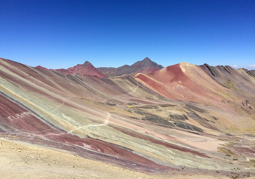
Located in the Andes Mountain Range in Peru, this mountain is known for its rainbow colored appearance. It was discovered by hikers only 6 years ago.

Author: Peruwikila / (CC BY-SA 4.0)

It lies in the Cusco district in Peru and is part of the Andes.

The mountain has a height of 5020m.

The mountain was initially covered in ice and snow but due to global warming the thick layers of ice melted away revealing beautiful color patterns on the mountain’s surface.

The different colors are attributed to the presence of different type of minerals on the mountain.

Each type of mineral on the mountain has a unique color and hence different types of color patterns can be seen on the mountain’s surface.

Vinicunca Mountain
Author: Viaggio nel Mondo / (CC BY-SA 2.0)

The red colored patterns are due to the presence of iron oxide. Green color is associated with chlorite. White is associated with sandstone.

And more color patterns are produced by other types of minerals. Also, some mineral sediments mix together producing new colors on the mountain surface.

The mountain was discovered in 2013.

Ever since the Vinicunca mountain was discovered, it has become an important hiking spot and tourist paradise. However, this has had a negative impact on the mountain’s beauty. Continuous hiking has caused erosion on the mountain surface and is damaging its geography.

Vinicunca Mountain
Author: Christian Morales Callo / (CC BY-SA 4.0)
  • « Previous Page
  • 1
  • 2
  • 3
  • Next Page »

Copyright © 2025 Informative Facts